


©BDDH: Modern Reconstruction of a D-Day Marshalling Camp
Marshalling Areas Explained
In the months prior to June 1944, Allied troops were based across Britain. The majority were based in Southern England with others in South Wales and the east of England. This vast zone was known as the Concentration Area and included large vehicle depots consisting of tanks, trucks and other vehicles, stored, and awaiting allocation to troops. This area contained hundreds of camps and training areas, some of which contained bunkers, walls and other structures such as concrete mock landing craft, to be used to prepare troops for landing somewhere in Europe. In addition there was a vast network of phantom troops and equipment based across east Sussex and Kent as part of a deception plan involving the liberation of Pas de Calais, codenamed Fortitude South. Additional Phantom Units were based in Scotland as part of a deception plan involving the liberation of Norway, codenamed Fortitude North.
The D-Day period ran from 6 June until August/September 1944. The movement of troops and equipment has been described as a conveyer belt. This system called for batches of troops to be moved out of concentration, with vehicles and equipment into Marshalling Camps and onto Embarkation.
At the same time aircraft and supporting infrastructure was being deployed at recently constructed temporary and existing airfields. Much like the temporary airfields, this information is currently under construction.

© IWM KY 13278 Crated Vehicles in storage Spring 1944

© IWM A70 19-1 Workman widening a road for increased traffic
The Move Forward
As D-Day approached, Machinery was prepared for the harsh saltwater landing conditions and the first batch of men and vehicles were moved to new camps located in over 20 Marshalling Areas within 10-20 miles of the coast. At this stage all supporting troops were held in reserve to join the units after the breakout from the beachheads had been achieved. Once in the Marshalling Camps men and vehicles were allocated to specific Landing Craft or Ships to ensure that everything was in the right place at the right time.
In the Marshalling camps final preparation began including allocating rations, checking and fuelling vehicles and final waterproofing. During their time in these camps their food, welfare and entertainment was provided for on site. Whilst the troops were accommodated in tents the majority of the camp facilities were in brick buildings such as Showers, Cookhouses, Bakeries and Toilets. Marshalling Camps were each allocated numbers of men and vehicles and it is understood that the Marshalling conveyer belt system took account of the numbers of troops and men to be loaded at their allocated Landing Craft.
© IWM A70 19-1 Camp Facilities were Semi-permanent buildings, whilst troops used tented accommodation

© IWM A70 23_2 Young Girl Meets Troops
Marshalling Camps
As was explained above, Marshalling Areas needed to be close to Embarkation because of limitations of travel due to waterproofing of engines. An exclusion zone was set up within 10 miles of the coast, and whilst this was a restricted area, those who lived within these areas went about their normal business and there is some evidence of local people interacting with the troops in Marshalling. There are several examples of local people that say, they saw and talked to troops, then one day they had all disappeared. This seems to contradict the conveyer belt system explained above. However, there is evidence that some of the Marshalling Camps were not used for subsequent waves, but further research is still required to build the full story.
Do you have family stories connected with Marshalling Areas and camps? Please contact us with your story.

©IWM H 37994 A Priest 105mm self-propelled gun of 303rd Battery, 76th Highland Field Regiment, 3rd Infantry Division,in the road close to A1/A2 Camps Emsworth, Hampshire, 29 April 1944.

©IWM (H 38831) Lance Corporal Collings 101st Light Anti-Aircraft Regiment (12th King's Regiment (Liverpool)) 3rd Division, reading at his French handbook at Camp A2 Emsworth, Hampshire, 29 May 1944.
Marshalling Infrastructure
Marshalling Areas included an Area HQ, Sub-Area HQ and camps, together with Embarkation Sites, dealt with elsewhere. These areas were mapped in great detail which include prescribed routes, one-way systems and parking areas. Roads were also widened and modified to provide passing places some of which are still visible today. Locations with dual carriageway bypasses were also used as parking areas by closing off one carriageway. There is also evidence of bridges being strengthened to cope with increased heavy traffic .
About twenty Marshalling Areas will be included on the Interactive Maps page, but for now we have concentrated on Area A, Portsmouth.

©IWM A70 19-5. Dual Carriageway storage area
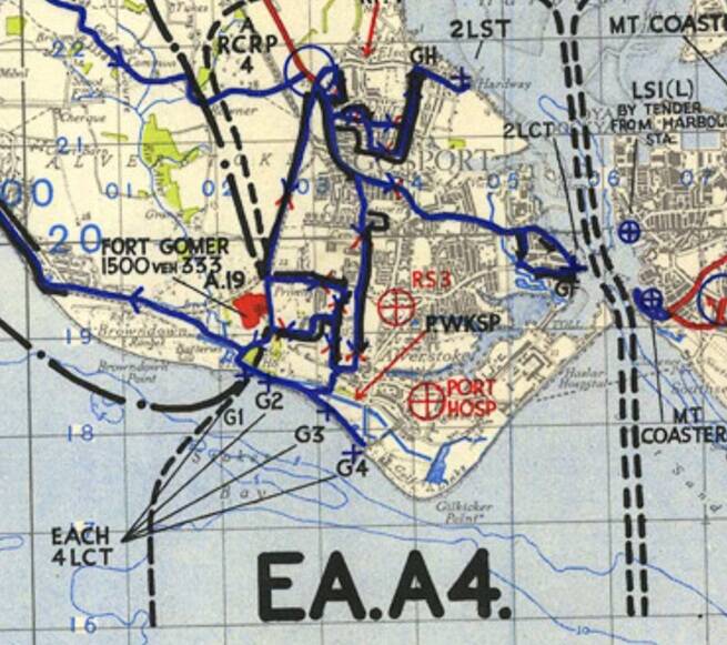
Extract of The D-Day Story Image:1995/69/1 showing Camp A19 & prescribed routes. to Embarkation Sites G1, G2, G3, G4, GF & GH.
Page Updated: March 2025
Create Your Own Website With Webador